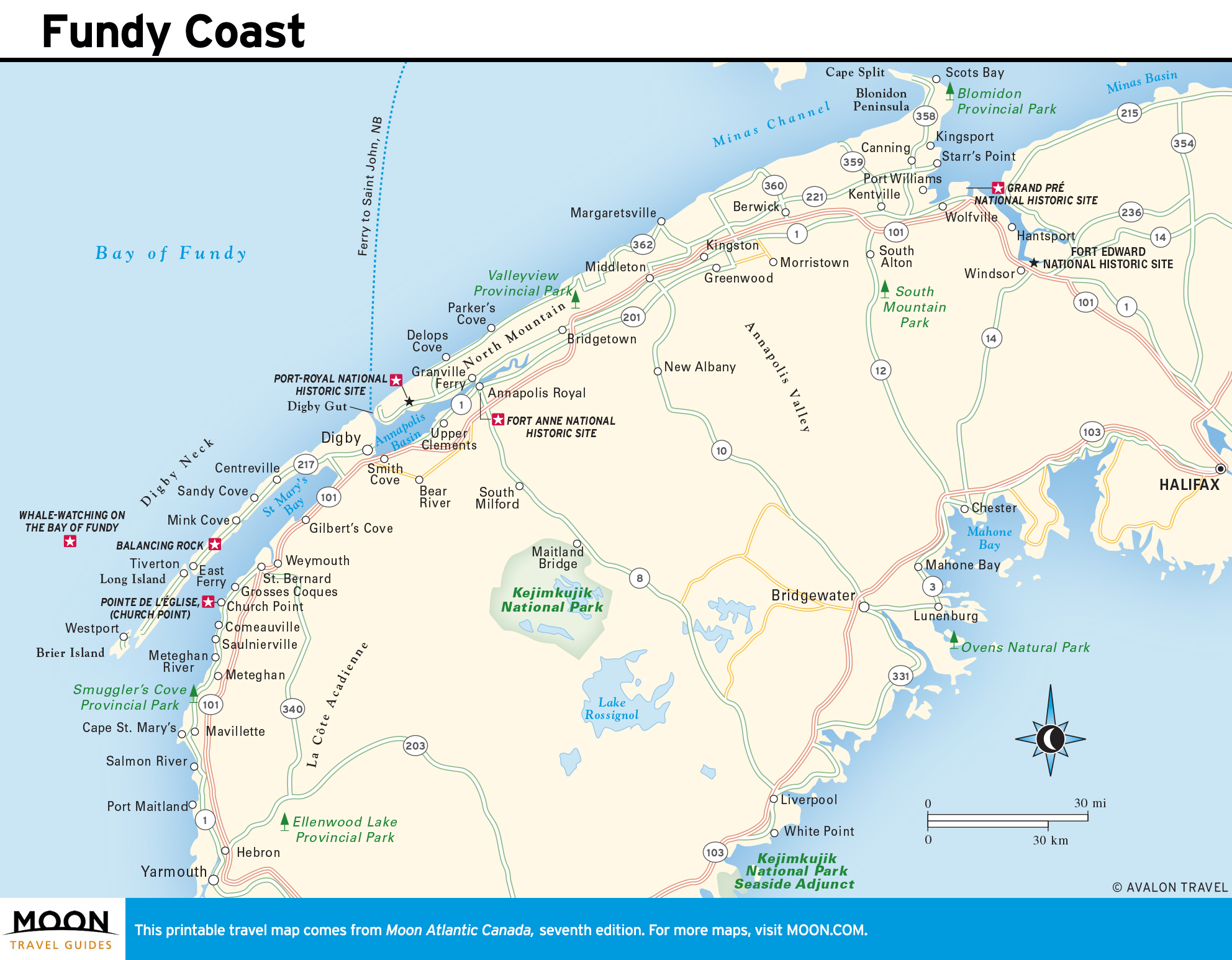
Atlantic Canada’s Colossal Fundy Tides
More than any other region of Canada, the Atlantic provinces are defined by water, which divides as well as unifies them. The planet’s mightiest tides surge through the Bay of Fundy between New Brunswick and Nova Scotia. The Cabot Strait separates Nova Scotia’s Cape Breton and the island of Newfoundland’s southern coastline. The unexpectedly warm Northumberland Strait, heated by the Gulf Stream, is a broad blue parenthesis dividing Prince Edward Island from Nova Scotia and New Brunswick. On the island’s north side spreads the Gulf of St. Lawrence. The Baie des Chaleurs, its warmth owing to its shallow depth, lies between northeastern New Brunswick and Québec’s Gaspé Peninsula.
Along Labrador’s coast, currents from the chilly Labrador Sea move southward and fork into a channel known as the Strait of Belle Isle, which separates the island of Newfoundland from the mainland, while the rest of the current washes along Newfoundland’s eastern coast.
If it were possible to walk the profoundly reticulated coastlines of the four provinces, following every cove, bay, point, and peninsula, the footsore traveler would log some 40,000 kilometers before eventually returning to the starting point.
The sea’s pervasive presence is felt throughout the region, but the ties to the ocean are perhaps strongest in Nova Scotia and Newfoundland, whose outer coasts confront the open Atlantic. The waters off Newfoundland in particular—the Gulf of St. Lawrence and the Grand Banks along the continental shelf—are among the most productive fisheries in the world, for five centuries an unbelievably rich resource for tuna, mackerel, herring, lobster, and cod.
On Prince Edward Island, surrounded by water, fishing is a major industry. But agriculture is an equally important component of the economy, the benevolent result of the last ice age, which blessed the land with a deep fertile loam. New Brunswick faces the sea on two sides and joins the mainland with a massive sweep of land rich in forests and ores, and hence has an economy comprised of fishing, forestry, and mining.
Colossal Fundy Tides
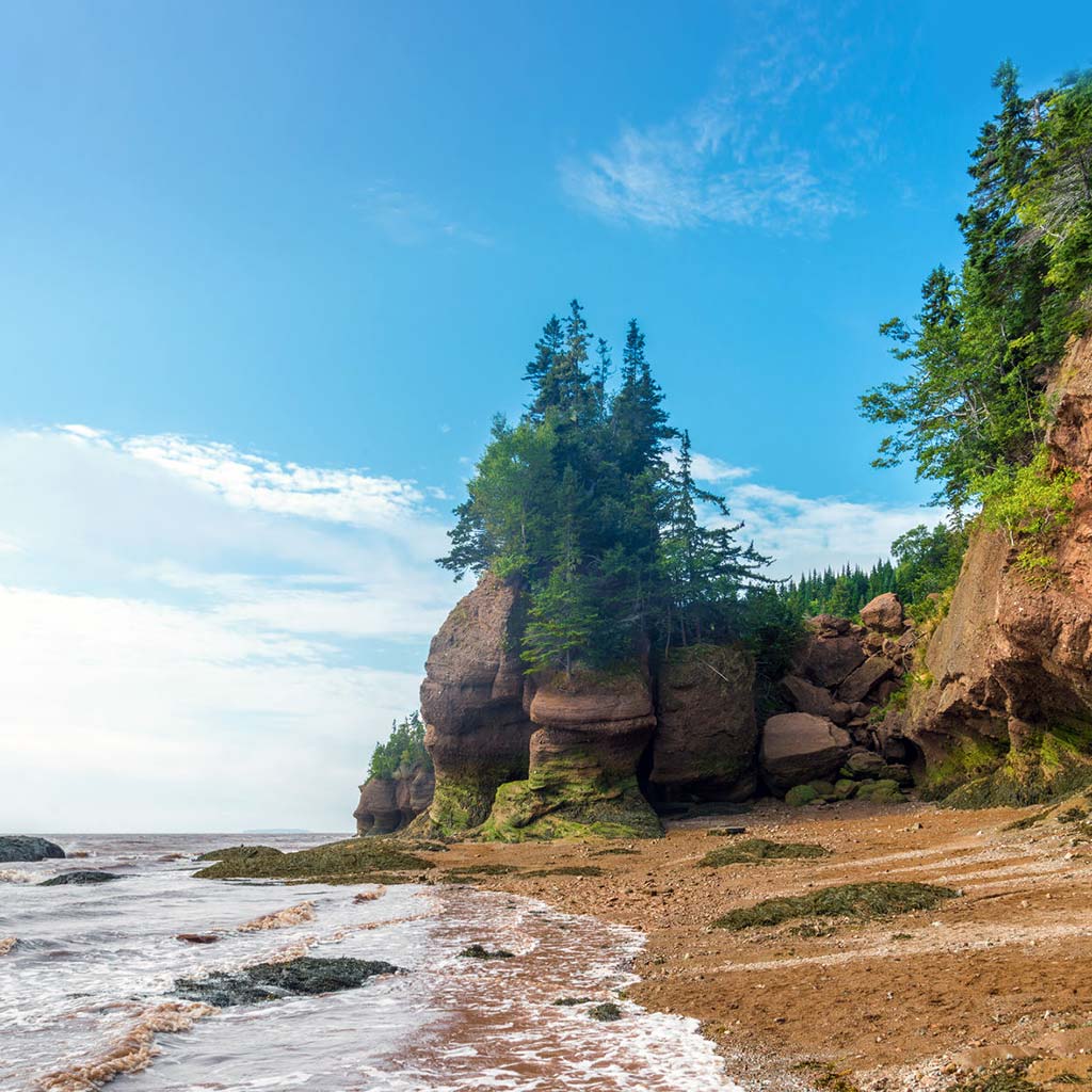
The world’s highest tides rise in the upper Bay of Fundy, with up to a 17-meter vertical gain at the head of the bay. The tides work on roughly a six-hour cycle, and each peak or low arrives 50 minutes later each day. Twice daily, six hours after high tide, the bay is empty, but then the Fundy surges onward and water funnels into the bay and up numerous rivers. The upper Fundy is split into two arms by Cape Chignecto, the wedge-shaped point that angles into the bay. On its west side, Chignecto Bay with its raw lonesome coastline penetrates inland and finishes at Cumberland Basin near Amherst. On the cape’s other side, the bay compresses itself first into the Minas Channel. It is here in the upper reaches of the bay that the tides are highest. By the time rising water funnels into the head of the bay, it is in the form of a tidal bore (lead wave) that rides inland up the area’s rivers. The arriving wave can be a dainty, ankle-high ripple or an upright wall of knee-high water, depending on the tide.

Due to the convoluted coastline, viewing the phenomena is possible at dozens of points around the Bay of Fundy, including Truro (Nova Scotia) and Moncton (New Brunswick), where riverside parks have been set aside for watching the bore. At Hopewell Rocks (New Brunswick), you can “walk on the ocean floor” at low tide. If you’re feeling more adventurous, you can even take a rafting trip down the Shubenacadie River (Nova Scotia) as the bore moves upstream. Tide tables are posted in shops and storefronts throughout the region. Tides are highest around the full or new moon.
Warning: The Bay of Fundy at low tide can be perilously alluring, when the coastal sea floor looks tranquilly bare and mudflats glisten like glass. High tide’s arrival is subtle and hardly noticeable. The distant tidal stirrings alert sea birds, and they cry out and wheel and turn across the sky. But then the sea moves in relentlessly, swelling and pushing forward into the bay at 6 knots per hour—and up to 13 knots in tidal rips. The incoming sea can wash across the empty bay faster than a person can swiftly walk. Only a foolhardy sightseer walks the mudflats; the high tide stops for nothing.